
The Philippines archipelago spans over 7,600 islands, creating a paradise of biodiversity where volcanic forces, coral reef ecosystems, and tropical forests have shaped extraordinary landscapes unlike anywhere else on Earth. This nation sits within the Pacific Ring of Fire and at the apex of the Coral Triangle, two global phenomena that have endowed it with both dramatic geological features and unparalleled marine diversity.
From underground rivers to chocolate-colored hills, from perfect volcanic cones to living coral atolls, the Philippines offers natural spectacles that seem almost otherworldly in their beauty yet remain relatively undiscovered by global tourism.
Here is a list of 15 natural wonders in the Philippines that showcase the country’s remarkable environmental heritage and unique ecological treasures.
Puerto Princesa Underground River
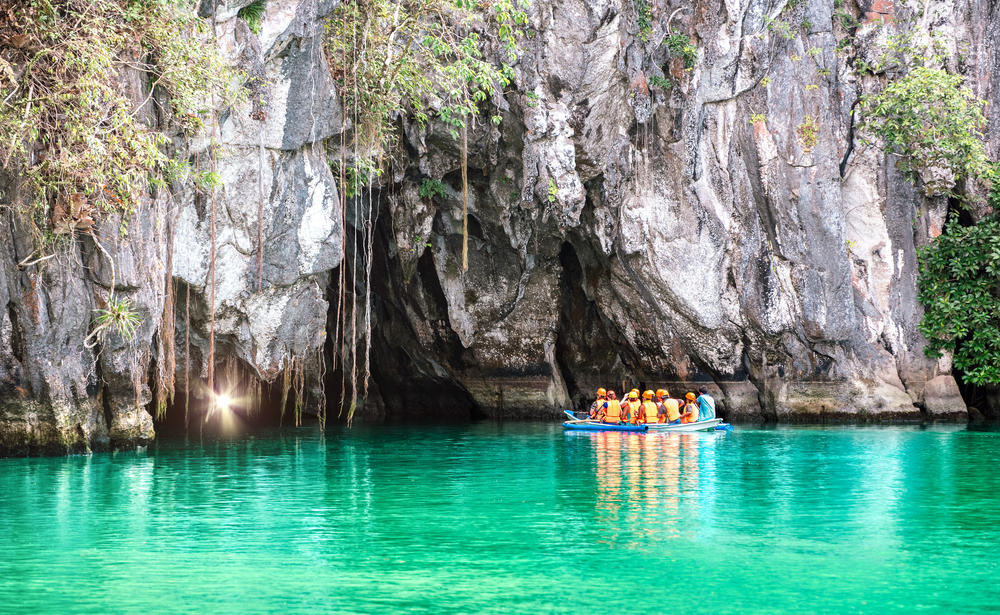
Flowing beneath a limestone mountain on Palawan Island, this remarkable river system extends for more than five miles before emptying directly into the South China Sea. Recognized as both a UNESCO World Heritage Site and one of the New Seven Wonders of Nature, the underground river features caverns, adorned with stalactites and stalagmites that formed over millions of years.
Boat tours navigate the initial section, where guides illuminate dramatic formations with spotlights while pointing out the numerous bat colonies that call the cave home. The surrounding national park protects ancient forests harboring over 800 plant species and rare wildlife, including the Philippine cockatoo and bearded pig.
Chocolate Hills
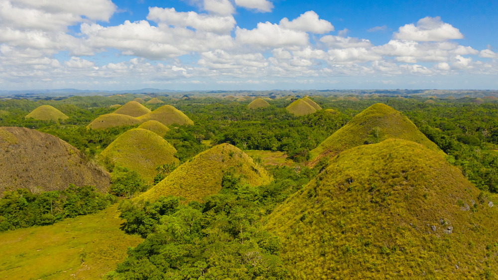
Rising from the otherwise flat landscape of Bohol Island, these perfectly cone-shaped hills—numbering between 1,200 and 1,700, depending on who’s counting—create one of the Philippines’ most distinctive landscapes. The hills, typically covered in green grass, earn their name during the dry season when vegetation withers to a chocolate brown hue that transforms the scenery into what appears to be endless rows of giant chocolate drops.
Geologists believe these formations resulted from weathered marine limestone left behind after the ocean receded millions of years ago. Local folklore offers more colorful explanations, including tales of battling giants who hurled boulders at each other, creating the unusually uniform mounds that now draw visitors to central viewpoints offering panoramic vistas across this strange terrain.
Like Travel Pug’s content? Follow us on MSN.
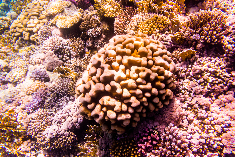
Tubbataha Reefs Natural Park
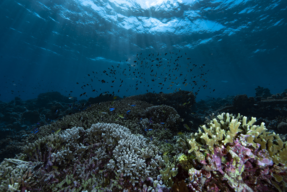
Located in the middle of the Sulu Sea, this remote marine sanctuary preserves one of the world’s most biodiverse coral reef ecosystems, with over 600 fish species, 360 coral species, and 11 shark species recorded within its boundaries. The reef’s isolated location—requiring a 10-hour boat journey from the nearest port—has protected it from the fishing pressure and pollution affecting many Philippine coastal areas.
Massive coral walls drop thousands of feet into the deep blue, creating dramatic underwater topography where pelagic species like manta rays and whale sharks regularly pass through pristine coral gardens. The reef’s two massive atolls serve as crucial nesting grounds for endangered sea turtles and seabirds, highlighting the critical ecological importance of this UNESCO World Heritage Site.
Mayon Volcano
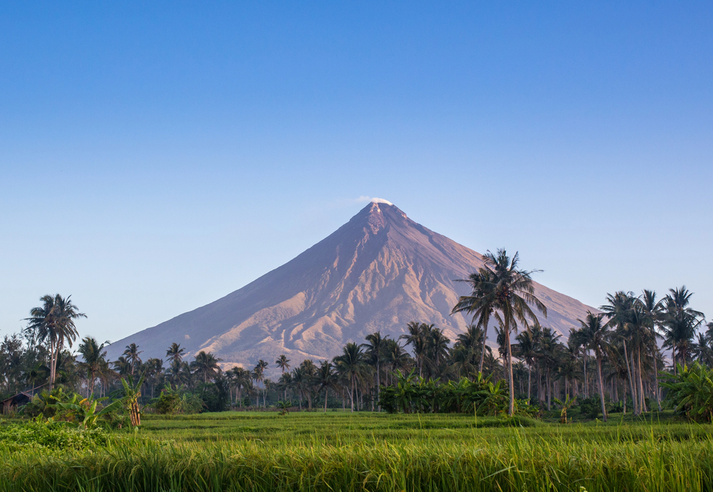
Rising 8,077 feet above the Albay Gulf, Mayon presents the world’s most perfect volcanic cone—a symmetrical pyramid that has inspired artists, photographers, and poets for centuries. The volcano’s beauty carries danger, however, as it remains the Philippines’ most active volcano, with over 50 eruptions recorded since 1616.
Lush vegetation covers the lower slopes, creating a striking contrast with the barren summit where steam often rises from the crater. Local communities have developed a complex relationship with the mountain they call Daragang Magayon (Beautiful Lady), respecting its destructive potential while celebrating the fertile soil it provides for agriculture.
Banaue Rice Terraces
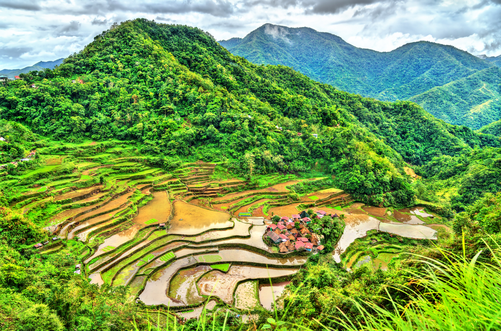
Carved into mountainsides by indigenous Ifugao people over 2,000 years ago, these agricultural masterpieces transform entire valleys into living sculptures that follow the natural contours of the land. If placed end to end, the terraces would stretch halfway around the globe, demonstrating the immense human effort behind their creation using only primitive tools.
The ancient engineering includes sophisticated irrigation systems that channel mountain spring water through each terrace level before cascading to fields below. While often called the “Eighth Wonder of the World,” these terraces represent more than just scenic beauty—they embody a living cultural landscape where traditional farming practices continue largely unchanged despite modern pressures.
Like Travel Pug’s content? Follow us on MSN.
Taal Volcano
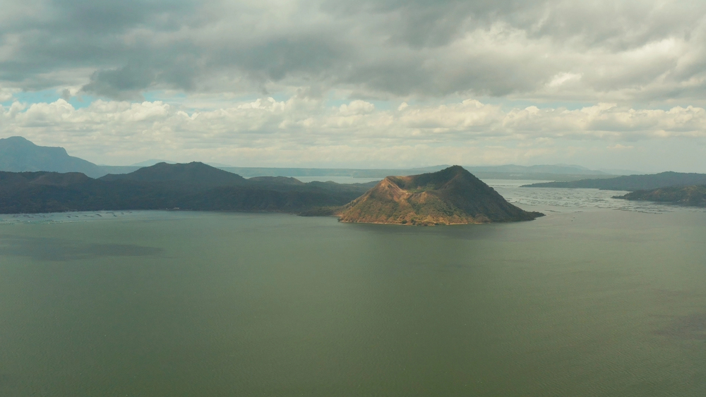
Creating one of geography’s most unusual formations, Taal features a lake within a volcano within a lake within an island—a nested arrangement that demonstrates the complex geological forces shaping the Philippines. The main crater lake contains startling yellow-green acidic water surrounding a perfectly formed inner volcanic cone accessible by boat and a short hike.
Despite standing only 1,020 feet tall, making it one of the world’s lowest volcanoes, Taal ranks among the planet’s most dangerous due to its history of violent eruptions affecting the densely populated surrounding region. The volcano’s distinctive profile dominates viewpoints from the surrounding highlands, where cool mountain air and scenic overlooks create popular weekend escapes from nearby Manila.
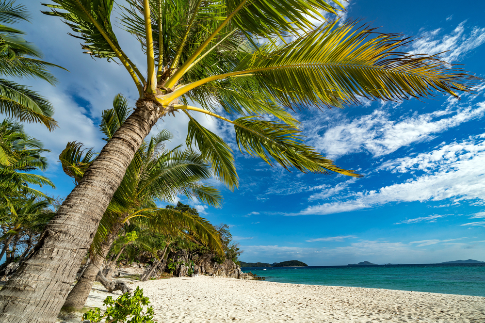
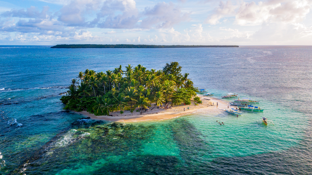
El Nido
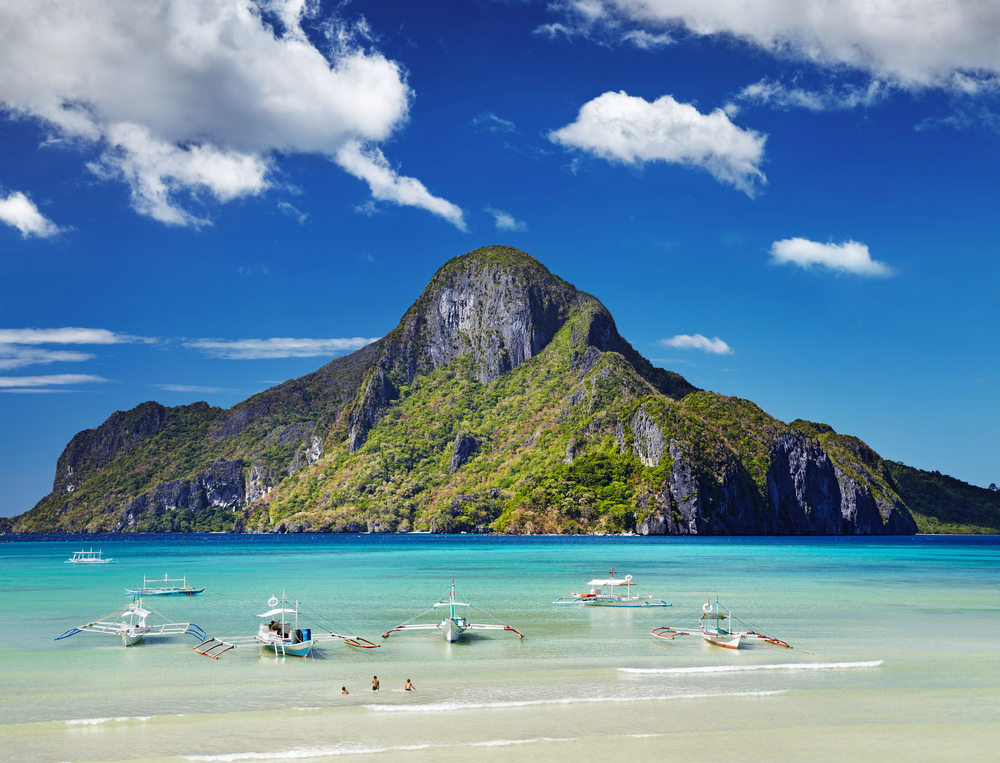
Dramatic limestone cliffs rise hundreds of feet directly from turquoise lagoons in this northern Palawan paradise, creating what many consider the world’s most beautiful island seascape. Hidden beaches are concealed within hollowed-out islands, accessible only through small openings barely wide enough for kayaks to pass through.
The karst landscape continues underwater, where coral reefs grow along the bases of these ancient marine cliffs, creating extraordinary snorkeling opportunities just yards from shore. The region encompasses 45 islands and islets scattered across Bacuit Bay, each offering distinctive formations from needle-like rock spires to massive arches carved by centuries of wave action.
Hinatuan Enchanted River
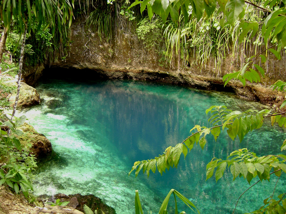
Emerging mysteriously from underground caverns on Mindanao Island, this short river flows directly into the Philippine Sea with water so intensely blue it appears digitally enhanced in photographs. The river’s unusual coloration comes from its depth and mineral content, while its crystal clarity allows visibility to 50 feet below the surface.
Local legends claim enchanted beings guard the river, explaining why no one has ever determined exactly how deep it extends into the earth despite numerous scientific dives and exploratory efforts. The river’s daily ritual—when staff play the Angelus prayer at noon, signaling swimmers to exit while they feed the massive fish that suddenly appear from the depths—adds to its mystical reputation.
Like Travel Pug’s content? Follow us on MSN.
Batanes Landscape
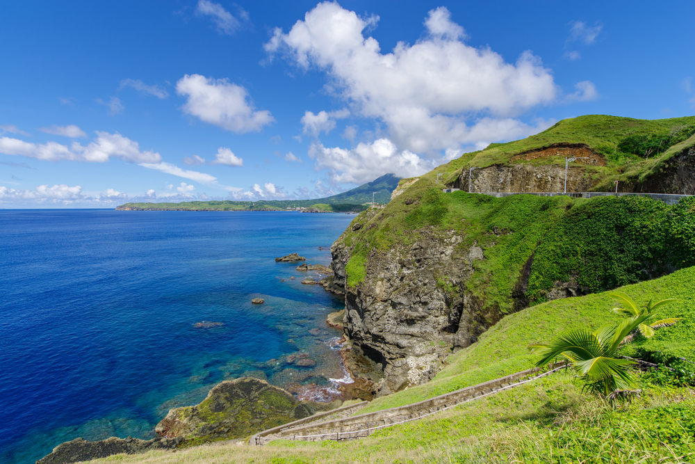
The Philippines’ northernmost province sits where the Pacific Ocean meets the South China Sea, creating dramatic coastal scenery where waves crash against vertically bedded volcanic rock formations. Rolling green hills reminiscent of New Zealand or Ireland blanket these islands, where traditional stone houses built to withstand typhoons dot the landscape.
The islands’ isolation has preserved both natural environments and cultural traditions largely unchanged by mainstream Filipino influences. Batanes experiences four distinct seasons despite its tropical location, with winter bringing strong winds that have shaped both the landscape and the resilient character of the Ivatan people who have adapted to this beautiful but challenging environment.
Coron Bay
Sunken Japanese warships from World War II have created one of the world’s most unusual diving destinations, where coral-encrusted military vessels rest in crystal-clear waters ranging from 30 to 120 feet deep. Above water, jagged limestone islands with hidden lagoons accessible only through small openings create a maze-like environment perfect for kayaking adventures.
The region’s most photographed attraction, Kayangan Lake, offers freshwater swimming surrounded by limestone cliffs in water so clear that boats appear to float on air. The unique convergence of historical significance, extraordinary water clarity, and dramatic island topography have transformed Coron from an obscure fishing community into a world-class destination for underwater explorers.
Mount Apo
Standing at the Philippines’ highest peak at 9,692 feet, this potentially active stratovolcano lords over Mindanao Island with a presence felt both physically and culturally throughout the region. Three distinct climate zones blanket the mountain’s slopes, creating extraordinary biodiversity, including over 270 bird species, with several found nowhere else on Earth.
Indigenous communities consider the mountain sacred ground, and their name for it—Apo, meaning “grandfather”—reflects their reverence for this massive landmark. The mountain’s diverse ecosystems include tropical rainforests, montane forests, and alpine meadows, culminating in a boulder-strewn summit featuring steaming sulfur vents that remind visitors of the powerful geological forces still active beneath their feet.
Like Travel Pug’s content? Follow us on MSN.
Apo Reef
Covering 67 square miles of the Mindoro Strait, this reef system stands as the world’s second-largest contiguous coral reef after Australia’s Great Barrier Reef, yet remains largely unknown to international travelers. The protected marine sanctuary creates a habitat for over 500 marine species within remarkably shallow waters, making it accessible even to novice snorkelers.
Massive manta rays with wingspans exceeding 15 feet regularly visit cleaning stations where smaller fish remove parasites from their bodies. The reef’s centerpiece, Apo Island, features a pristine white sand beach and a small lagoon surrounded by mangroves that provide crucial nursery habitat for juvenile reef fish before they venture into the open ocean.
Siargao Cloud 9 Wave
Nature created the perfect surfing wave off this teardrop-shaped island when deep Pacific Ocean currents encounter a reef shelf that forces the water upward into a consistently perfect right-hand break. Named after a popular chocolate bar by the first surfers who discovered it, Cloud 9 produces hollow tube rides that have earned it recognition among the world’s top surfing destinations.
The wave breaks over a sharp coral reef just yards from a viewing platform where spectators can watch surfers barrel through translucent tubes during competition season. Beyond this iconic break, the island also boasts numerous lesser-known surf spots amid lush mangrove forests, tidal pools, and pristine beaches that have maintained their natural character despite growing international attention.
Kawasan Falls
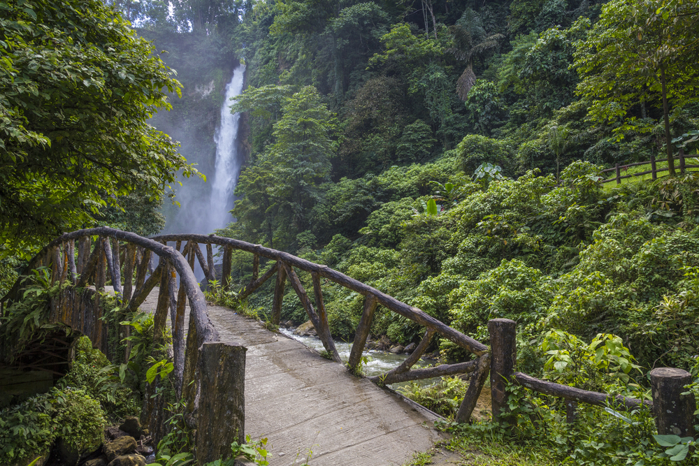
Descending through jungle-covered mountains on Cebu Island, this three-tiered waterfall system features stunning turquoise pools whose color comes from the high mineral content of the limestone watershed. The most photographed section features a 40-foot cascade emptying into a pool so perfectly blue it appears artificially colored.
Traditional bamboo rafts ferry visitors directly under the thundering main falls, where the cool mountain water provides relief from tropical heat. The falls form part of a larger river system where adventure seekers can experience canyoneering—jumping from cliffs, swimming through gorges, and sliding down natural rock formations polished smooth by centuries of flowing water.
Like Travel Pug’s content? Follow us on MSN.
Caramoan Peninsula

Located in the eastern Philippines’ Bicol Region, this rugged peninsula features limestone karst islands scattered across crystalline waters, creating landscapes so striking they’ve hosted multiple international “Survivor” television series. Hidden lagoons reveal themselves only at specific tide levels, while white sand beaches appear and disappear with changing water levels.
The mainland portion offers dense jungle trails leading to caves containing ancient burial sites and rock shelters used by indigenous peoples for thousands of years. Despite growing recognition, much of the peninsula remains undeveloped, with local fishing communities continuing traditional practices in waters where dolphins regularly frolic near traditional wooden outrigger boats.
Where Geology Creates Masterpieces

The Philippines’ natural wonders represent more than just scenic landscapes—they demonstrate the extraordinary creative force of geological processes operating in a tropical archipelago setting. From volcanism that builds perfect cones to erosion that carves limestone into fantastical shapes, from coral polyps constructing living underwater cities to tectonic forces elevating marine sediments into mountain ranges, the country serves as an open-air museum of earth science processes.
While facing significant environmental challenges from development pressure, climate change, and resource extraction, these Filipino natural treasures remind us of what’s at stake in conservation efforts. Travelers fortunate enough to witness these wonders firsthand often find themselves transformed from mere tourists into advocates for preserving what nature has spent millions of years perfecting.
More from Travel Pug

- Cities Growing so Fast You Won’t Recognize Them in 10 Years
- 13 Destinations Where Tourists Regularly Regret Their Trip
- 16 U.S. Cities That Are Quietly Becoming Travel Hotspots
- Where to Travel If You Love Long Bus Rides and Daydreams
- 20 Cities Perfect for Solo Travelers Who Crave Adventure & Culture
Like Travel Pug’s content? Follow us on MSN.