

Some cities are built for cars. Others are built for people. The difference hits you immediately—one requires constant navigation of parking lots and traffic, while the other lets you just wander and see where you end up.
Walkable cities don’t just make getting around easier. They change how you experience a place completely.
The cities that do this well aren’t always obvious. Here are 15 cities where walking is the real attraction.
Milan

Milan clocks in as the world’s most walkable city right now, with residents reaching essential amenities in an average of about six and a half minutes on foot. The fashion district, the Duomo, and the Brera neighborhood all sit close enough together that you can cover serious ground without ever thinking about transportation.
Shopping arcades provide covered routes when weather turns bad. The city balances historical architecture with modern design in a way that keeps walks interesting rather than repetitive.
Florence

Florence’s top attractions sit within half a mile of each other. You can walk from the Duomo to the Ponte Vecchio to the Uffizi Gallery in about ten minutes total.
The historic center is mostly pedestrianized, so you’re not constantly dodging cars or waiting at crosswalks. The compact layout means you can see major Renaissance landmarks while also stumbling onto smaller churches and hidden piazzas that don’t make guidebooks.
It’s genuinely hard to have a bad walk in Florence.
Venice

Venice eliminated cars entirely, so walking is basically your only option besides boats. The layout is confusing on purpose—narrow alleys twist around in ways that make navigation challenging even with GPS.
Getting lost is part of the experience though. The best parts of Venice hide in residential neighborhoods away from tourist crowds around St. Mark’s Square. You discover them by wandering without a specific destination in mind.
Barcelona

Barcelona introduced superblocks that prioritize pedestrians over vehicles. Wide boulevards connect distinct neighborhoods, each with its own character.
The Gothic Quarter has medieval streets barely wide enough for two people to pass, while newer areas like Eixample follow a grid pattern with corners cut off to create more pedestrian space. Gaudí’s architecture is scattered throughout, so you encounter something visually striking every few blocks.
New York City

Manhattan’s grid system makes walking straightforward. Most residents can reach groceries, restaurants, and services within a short walk from their apartments.
The subway fills in gaps for longer distances, but plenty of people walk 20 or 30 blocks without thinking twice about it. Different neighborhoods pack dramatically different vibes into small geographic areas—Chelsea feels nothing like the Lower East Side despite being maybe two miles apart.
Copenhagen
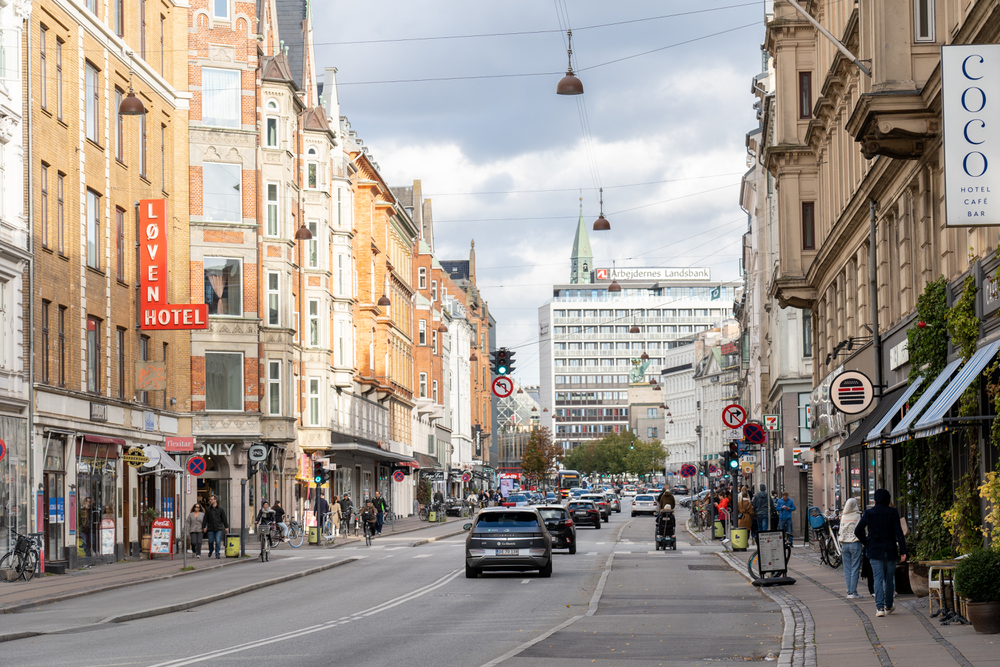
Copenhagen built Strøget, one of Europe’s longest pedestrian streets, decades ago. The city invested heavily in pedestrian infrastructure alongside bike lanes.
Harbor-front paths let you walk along the water for miles. Height restrictions on buildings keep the scale human-sized rather than overwhelming.
Summer brings outdoor cafes and street performers, though winter walkability drops when temperatures plunge and snow piles up.
San Francisco

San Francisco’s compact peninsula forced high-density development. Neighborhoods like Chinatown, the Castro, and Nob Hill pack restaurants, shops, and services into small areas.
The hilly terrain makes walking a workout, but it also creates views you’d miss entirely from a car. Public transit is extensive enough that plenty of residents go car-free.
One-way streets and congested traffic often make walking faster than driving anyway.
Boston

Boston predates cars by centuries, and the street layout shows it. Winding roads follow old cow paths rather than logical grids.
That chaos actually works in favor of pedestrians since it naturally slows traffic. The Freedom Trail connects historical sites through a marked walking route.
Neighborhoods like Back Bay and Beacon Hill maintain 19th-century architecture at walkable scales. Winter snow can be brutal, but the city stays walkable year-round.
Washington DC

The nation’s capital designed its layout with pedestrians in mind from the start. Diagonal avenues cut across the grid, creating shorter walking routes between destinations.
Building height limits prevent the skyline from overwhelming street-level experience. The National Mall functions as a massive pedestrian corridor connecting monuments and museums.
Neighborhoods like Dupont Circle and Georgetown pack amenities densely enough that residents can handle daily errands on foot.
Rome

Walking through Rome means stepping over 2,000 years of history at every turn. The Colosseum, Pantheon, Trevi Fountain, and Spanish Steps all sit within a couple miles of each other.
Cobblestone streets weren’t designed for cars, making pedestrian travel the natural choice. You’ll end each day with sore feet from covering miles of uneven ancient stone, but that beats sitting in Roman traffic.
Athens

Athens clusters its ancient sites within a relatively small area. The Acropolis dominates the skyline and you can spot it from most parts of the historic center.
Walking from the Parthenon to the Ancient Agora to Syntagma Square covers maybe two miles total. The layout works well for pedestrians despite Athens being a large modern city.
Summer heat makes midday walks brutal though—locals know to avoid walking during the hottest hours.
Edinburgh

Edinburgh’s medieval Old Town wasn’t built for vehicles. The Royal Mile runs through the historic center as a mostly pedestrian route connecting Edinburgh Castle to Holyrood Palace.
Narrow closes and steep staircases branch off the main streets, hiding pubs and shops in unexpected places. The city’s hilly terrain provides constant views over the surrounding area.
Cobblestones get slippery when wet, which happens frequently in Scotland’s rainy climate.
Chicago

Chicago’s grid system and lakefront access create excellent walkability for a city its size. Neighborhoods like the Loop, River North, and Wicker Park concentrate amenities within walking distance.
The 18-mile Lakefront Trail provides recreation separate from street walking. Public transit supplements walking for longer trips.
The city invested in pedestrian infrastructure and public parks that break up urban density with green space.
Paris

Paris spreads across a larger area than some other walkable cities, but its arrondissement system creates distinct neighborhoods that function independently. Strolling along the Seine connects multiple areas naturally.
Wide boulevards give pedestrians space despite heavy traffic. The Metro fills in gaps, but walking remains the best way to discover hidden courtyards and neighborhood cafes that tourists typically miss.
Portland

Portland has 200-foot blocks, among the shortest in any American city. Shorter blocks mean more frequent crossing opportunities and diverse route options.
The city prioritized pedestrian infrastructure and mixed-use development long before it became trendy. Neighborhoods maintain distinct identities while staying connected through walkable streets.
Rain is constant from fall through spring, but the city stays active regardless of weather.
Why walking matters

Walkable cities weren’t planned to be tourist attractions—they just developed that way through centuries of human-scale urban design or through intentional modern planning that put people before cars. The experience of moving through a city on foot connects you to the place in ways that driving never does.
You notice details, encounter unexpected moments, and develop an actual sense of geography rather than just memorizing highway exits. Cities optimized for walking also tend to be healthier, more sustainable, and more socially connected since people naturally interact more when they’re not isolated in vehicles.
The best walkable cities don’t just make it possible to skip the rental car—they make you glad you did.
More from Travel Pug

- Underrated Italian Towns That Beat the Tourist Crowds
- Las Vegas Tourist Traps to Skip
- Prettiest Towns in Every US State
- 18 passport-free countries for Americans
- Signs Your Cruise Is Not Worth The Cost
Like Travel Pug’s content? Follow us on MSN.